This is a question yet to be fully answered. It could have derived from an earlier name, Kangaroo Ground. The earliest use of ‘Kangaroo Ground’ is thought to be by James Meehan in 1819. But where did this name come from? Did Kangaroo Valley have a lot of kangaroos at that time? Did it just apply to the base of the valley? Was this because it was an area of fire-stick farming? Records to the effect that prior to European occupation the plain of the valley was covered in meadows and scattered trees, rather than dense forest, would seem to indicate that fire-stick farming was being practised by Indigenous people.
The history behind the name ‘Kangaroo Valley’ is a topic that is ripe for further research and anyone who has access to information is encouraged to contact Reconciliation Allies Kangaroo Valley.
Very valleyiferous place?
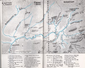
Interestingly, an account that appears in the 2011 publication Views and Visions – Stories of Wattamolla and Woodhill, which was a community project based on historical documents and the best available information at the time, attributes the name to Cornellius O’Brien. In 1824, the valley was being mapped by Cornellius O’Brien on behalf of the then governor Sir Thomas Brisbane. In Views and Visions, it is stated that the original name for the valley was Gun:guru:gara which means ‘very valleyiferous place’, but after Cornellius O’Brien erroneously called it Kangaroo Ground it stuck as the interpretation. As pointed out in Views and Visions, if we look at a map of Kangaroo Valley, we can clearly see that five arms of the terrain are fingers of a right hand. The palm can be placed on Barrengary meadows, the thumb on Barrengary Creek, index finger on Upper Kangaroo River and the others on Gerringong, Brogers and Sawyers Creeks. Hence, the meaning of ‘very valleyiferous place’ seems apt.
As to the source of this story, it may be from information that was given to Archibald Campbell by Buthring, an Indigenous person from Cullunghutti Mountain (near Berry) or also from Wilson, a convict, who is thought to be the earliest white man to learn an Indigenous language (perhaps Dharawal), and who assisted Governor Philip.
In 1846, according to Views and Visions, in each of the valleys were five camps of Aboriginal people as recorded in the memoirs of Charles McCaffrey, the first dairyman in the Valley.
In Views and Visions it is noted that Cornellius O’Brien was also known as the Appin Scalper, and that he was the leader of a massacre of Aboriginal people in 1818 at Shellharbour (probably the Minamurra River). There was also a massacre at Appin in 1816 ordered by Governor Lachlan Macquarie as recorded in the Dictionary of Sydney. Whether or not Cornellius O’Brien had a role in either of these events would need confirmation.
Indigenous place names of Kangaroo Valley
The old map of Kangaroo Valley provided in John Griffith’s A History of Kangaroo Valley, published by the Kangaroo Valley Historical Society in 1978, is fascinating for its location of pre-1840 walking tracks, early roads built by the settlers, and points of cedar-getting activity. It also marks some sites of Aboriginal artefacts, places where settlers met Aboriginal people, and Aboriginal cave paintings.
We can see many Indigenous names, and each is likely to have its own story to tell: Bong Bong, Bundanoon, Yarrangga, Tallowa, Moollattoo, Carrialoo, Noggarah, Gerringong, Bellawongarah, Tapitallee, Wattamolla, Budderoo and possibly Barrengarry. There are other names that refer to remarkable Indigenous people such as Trimbles Creek and Brogers Creek. Undoubtedly, we would benefit from a full understanding of the background to each of these names.
Sarah Waddell
on behalf of
Reconciliation Allies Kangaroo Valley
